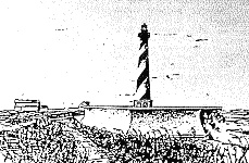
Paul C. Cloyd PE/RA International Council on Monuments and Sites 12th General Assembly and Symposium Mexico, October 17-23, 1999 |
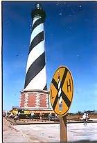 photo by Mike Booher |
|---|
Paul C. Cloyd PE/RA International Council on Monuments and Sites 12th General Assembly and Symposium Mexico, October 17-23, 1999 |
photo by Mike Booher |
|---|
Introduction
History of the Light Station
Significance
Description of the Station
Environmental Threats to the Light Station
Previous Responses to the Natural Threats
The Preservation Options
Factors Considered in the Preservation Option Selection
Design-Build Contracting Method:
Technical Move Methods
Conclusion
Bibliography
Links
Introduction
The barrier island of the Outer Banks curves out into the Atlantic Ocean off North Carolina. This broken strand of land is subject to powerful currents and storms that cause erosion of east-facing shorelines. Here rests the Cape Hatteras Light Station.
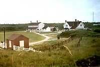
The Cape Hatteras Light Station, consists of a lighthouse tower, principal keeper’s dwelling, duplex assistant keeper’s dwelling, and oil house. It exists as a relatively complete light station with its major support buildings intact.
The Cape Hatteras Light Station includes the tallest brick lighthouse in the US, second tallest in the world . One hundred and thirty years ago, 490 meters separated the lighthouse from the shoreline. By 1997 the sea had reduced this to 36 meters. The station faced inevitable destruction due to coastal erosion unless some action was taken
June 1998, the National Park Service awarded a contract for the design and relocation of the light station structures. Construction commenced in December of 1998 and the relocation of all the structures was completed by October of 1999. All light station buildings including the light house have been relocated essentially intact.
The Cape Hatteras Light Station now sits .9 kilometers to the southwest of its original location. This will paper will discuss how the US National Park Service arrived at the decision to relocate the station and how they executed the project.
History of the Light Station
As early as the 1500’s, when ships depended on wind for power, mariners learned to take advantage of ocean currents. North and East bound vessels followed the Gulf Stream. Southbound ships followed the Virginia Coastal Current. Ships passed close by the Outer Banks and the treacherous shoals off Cape Hatteras.
In 1797, Congress recognized the need for a navigational aid in the vicinity of Cape Hatteras. The first lighthouse of sandstone construction was completed in 1803 and stood about 1.6 kilometers inland from the ocean beach. Inspections in the late 1860’s showed growing cracks in the sandstone structure, and construction of a new lighthouse was recommended.
Dexter Stetson served as foreman of construction for the new Cape Hatteras Lighthouse. Upon the first excavation for the new foundation of massive granite, Stetson discovered that he could only dig about six feet before hitting hard, compact sand. Though he had the use of pile drivers, he used the naturally hardened subsurface upon which to lay three courses of yellow pine timber that would serve as the first layer of the foundation. Submerged below the fresh water table, Stetson believed the timber would remain steel-strong. And so they did, the contractors found the timbers in sound condition as they were uncovered during the excavation for the 1999 relocation.
Construction of the second (and existing) Hatteras Lighthouse finished in 1870 with activation of the light 1870. Soon after the US Lighthouse Service demolished the 1803 structure fearing its inevitable natural collapse could cause harm. The demolition left only foundation remnants until 1980 when a fierce storm submerged the 1803 site.
| Significance Because the shoreline along the Outer Banks is generally flat, there were no landmarks visible to mariners unless they steered too close to the dangerous shore. Known as the graveyard of the Atlantic, estimates suggest that more than 2,200 craft of various sizes and types have met disaster in the vicinity of Cape Hatteras. Seen as a crucial coastal aid to navigation and given a high priority, the light station at Cape Hatteras was first conceived in 1794 and completed in 1803. |
 |
The Atlantic Coast of the United States served as a major transportation corridor for commercial traffic from the late 18th through the 20th centuries. The construction of the Cape Hatteras Light Station directly reflects the early efforts of the federal government to provide an integrated national system of navigational aids. Cape Hatteras Lighthouse is among the most popular lighthouses in America. Its majestic setting at the bend of the Outer Banks provides a striking presence. The light station attracts close to 1,000,000 visitors to the site with more than 224,000 visitors entering the lighthouse each year. Cape Hatteras is perhaps the most significant in the chain of lights marking the Atlantic coastal shipping lane.
The present light station embodies a distinctive design and method of construction that typified first-order coastal lighthouse construction on the East Coast of the United States during the second half of the 19th century. The earliest materials used for lighthouse construction were wood and/or rubble stone masonry. Later cut stone and brick were used, allowing towers increased height for better visibility. The design of the tall brick towers consisted of a double wall with a hollow space between the wall. This design lightened the load and reduced the overall cost by using fewer bricks while still providing a highly durable structure.
Cape Hatteras Lighthouse serves as a national icon for American lighthouses. Its unique spiral banding on the tower is distinct and easy to recognize. Most Americans have viewed its image or a rendering of that image at one time or another. Although there are many lighthouse construction types, most think of the tower similar to the one at Cape Hatteras when imagines a lighthouse. In the minds of many Americans,the Cape Hatteras Lighthouse is the Nation’s lighthouse.
Of the one thousand lighthouses built by the US Lighthouse Service, the Cape Hatteras Lighthouse receives the most recognition in America. The US Department of Interior has designated the Cape Hatteras Light Station a National Historic Landmark. This week the American Society of Civil Engineers has designated the Lighthouse a Historic Civil Engineering Landmark.
| Description of the Station The Lighthouse foundation consists of two levels of yellow pine timber supporting large blocks of rubble granite laid in cement mortar. All interstices received smaller stones of granite resulting in a solid, well-consolidated foundation. |
 |
|---|
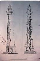
The total height of the structure from the base of the foundation to the top of the pinnacle is 63 meters. The tower rests on an octagonal granite base 7.3 meters in height and 14 meters in diameter at the lower plinth course. The dressed granite blocks for the quoins came from Vermont. Bartlett and Robbins cast the iron spiral interior stairway. One and a quarter million dark-red bricks for the tower came from kilns along the James River near Richmond Virginia. The tower extends 60 meters from ground level to the top of the pinnacle.
The tower is constructed of interior and exterior brick walls with interstitial walls resembling the spokes of a wheel typical for masonry lighthouse construction of this period. A marble plaque inside the entrance foyer is inscribed “Cape Hatteras Light House Erected AD 1870, Latitude 35°-15’-14” Longitude 75°-30’-56”.
In I873 the tower received its signatory spiral bands of alternating black and white. A total of four bands, two white, two black, make 1 ½ revolutions about the tower.
Henry Lepaute, Paris, France produced the original first order revolving lens. The lens turning mechanism consisted of a weight-driven clock with a wire rope ¼ inch in diameter and 160 feet in length attached to 150 pounds of double lead weight. Oil lamps originally illuminated the light. In 1934 the Coast Guard electrified the light. In less than two years later shoreline erosion resulted in the abandonment of the light house in 1936. The Coast Guard set up a new light on a nearby skeletal tower. Vandals heavily damaged the first-order lens left in the abandoned lighthouse. The US Coast Guard removed the remains of the classical lens in 1949. The Coast Guard installed a new lighting device in 1950 when they returned the light to the old tower. In 1972 the light received a rotating beacon with two 1000 watt lamps. The light’s focal plane is 58 meters above mean high water level.
In 1854 the structure now known as the Double Keeper’s Quarters was constructed on brick piers and enclosed whitewashed clapboards. The structure measures approximately 26 by 13 meters. In 1954 the National Park Service converted the interior of the structure to the museum for visitors to learn more about the National Seashore Center.
In 1871 the US Lighthouse Service completed a brick dwelling for the principal keeper. At least one account states the dwelling was originally to be built of wood but since there was extra brick left over from building the tower, it was built of brick. The principal keeper’s dwelling sits just east of the assistant keeper’s dwelling and north of the tower. A cistern connected to the roof gutter system adjoins the north end of the structure. The Principal Keeper’s Quarters measures approximately 11 meters feet by 10 meters.
Environmental Threats to the Light Station
The two primary threats to the light house were salt water intrusion leading to the deterioration of the timber mat and the undermining of the foundation as the shoreline erodes. Yellow pine timbers sat in fresh water on compacted sand. When construction began in 1868 foreman Stetson found he could not easily drive pilings through hard sand beginning at barely six feet below ground. The floating timber mat foundation provided a simple alternative for this situation. As long as the sand surrounding the foundation remained in place and the timbers remained bathed in fresh water the foundation would be secure. If salt water displaced the fresh water the timbers would begin to rot and the foundation would fail. Coastal geologists have called these wood timbers the “Achilles heel” of the lighthouse and have said, “Neither seawalls nor groins are long-term deterrents to its collapse.” With the ocean moving ever closer to the lighthouse, the danger of salt water intrusion increased. During a December 1994 storm, ocean waves actually reached the base of the lighthouse.
Lateral Loads
The pine timber mat lies only about six feet below ground, held down by the weight of the massive lighthouse. The 1988 National Academy of Science (NAS) committee’s report suggested this makes the tower vulnerable to the direct lateral force of storm winds. However, the empirical evidence of surviving 130 years of Atlantic storms provides strong evidence that this may not be the worst threat. Indeed the structural analysis of the lighthouse found that its center of gravity lays 20 meters (about 1/3 total height) above grade. The low center of gravity and its symmetrical cylindrical form providing a structure highly resistant to lateral loading of high winds. This also indicated the structure’s ability to withstand the stresses caused by the relocation.
Shore Line Erosion
Hatteras Island is a barrier island migrating southwesterly, driven by rising sea levels and prevailing water and wind currents. At its completion in 1870, the Cape Hatteras Lighthouse stood about 490 meters from high tide. Over the years the beach eroded and by the 1920’s the ocean had advanced to within 100 meters of the Lighthouse.
Despite millions of dollars invested in beach nourishment (pumping in sand), groins (walls built perpendicular to the shoreline intended to trap sand), huge sandbags, artificial seaweed (planted to stabilize sand just offshore) and other short-term protection methods, erosion has steadily brought the ocean closer and closer to the lighthouse.
Changes in sea level, among other factors affect the rate of beach erosion. Responding to the gradually rising sea level of the past several thousand years, barrier island systems have migrated westward. Hatteras Island is no exception. This migration occurs as storm-driven ocean tides wash completely over the islands, moving sand sediments toward the sound shoreline. Because of this migration, barrier islands are among the most unstable land masses on earth. Under these conditions, stationary structures built on them, such as the Cape Hatteras Lighthouse, are inevitably threatened. Coastal geologists held the expectation that east-facing shoreline in front of the lighthouse would continue to recede until storm-driven waves undermined the tower’s foundation and topple the lighthouse.
The 1990 Development Concept Plan shows a straight-line move that skews towards west away from the shore. The goal was to set the lighthouse house back 490 meters from the shoreline as it was originally. In 1990 the move distance for accomplish the 490 meter shoreline set back then required a 760 meter move. By 1997, the intervening 7 years of beach erosion required extending the move an additional 120 meters to 880 meters to accomplish the same 490 meter setback.
Previous Responses to the Natural Threats In 1870, the lighthouse stood 490 meters from the ocean. By 1919, the ocean had advanced to within 100 meters of the tower and to within 30 meters by 1935. A combination of natural changes and a number of human interventions postponed the threat for a number of years. |
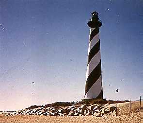 photo courtesy of the National Park Service |
|---|
Time Line
1930s
The Civilian Conservation Corps begins building a barrier sand-dune system along the entire length of Hatteras Island. The ocean advances to within 30 meters of the tower.
The US Coast Guard abandons the lighthouse. The National Park Service takes custody of the light station.
1950
The Coast Guard reactivates the lighthouse when the erosion problems seem to have stabilized.
1960s
About 312,000 cubic yards of sand were pumped from the Pamlico Sound onto the beach (beach renourishment) Large nylon sand-filled bags are placed in front of the lighthouse.
US Navy builds three reinforced concrete groins to protect the Naval Facility. This incidentally provided some short term protection to the lighthouse.
1970s
About 200,000 cubic yards of sand were moved from Cape Hatteras Point to the beach in the lighthouse area. Later again an additional 1,300,000 cubic yards of sand were moved from Cape Hatteras Point to the beach. Storms partially destroy the groins that the Navy built in 1969. They were repaired with sheet steel piling.
1980s
A severe storm in March 1980 destroys the remaining 1803 lighthouse ruins. The groin nearest the lighthouse was extended 150 feet after storms flank the beach anchor point. The ocean washes completely around the extension in December and forces an emergency protection project, which pushes the sea back from the lighthouse to about 30 meters away. The sea had reached to less than 25 meters to the lighthouse base.
The Corps of Engineers developed protection alternatives, including a seawall encircling the lighthouse. Other alternatives were moving the lighthouse, offshore breakwaters and more groins. In September, about 700 sandbags were placed in a protective dike around the lighthouse. The groin nearest the lighthouse was extended 45 more meters.
Funding for a seawall is secured. A private group, “Move the Lighthouse Committee,” presents documentation of relocation technologies not previously available. The National Park Service contracted with the National Academy of Sciences for an independent review of all protection options.
The academy recommends that the lighthouse be moved.
The National Park Service announces their preference for the relocation option.
1990-94
The National Park Service produced documents to comply with environmental and cultural resource regulations )
The National Park Service defers relocation to redirect money to emergency interim protection measures. Hurricane Emily damaged the lighthouse lantern deck handrail and windows.
The southern most groin, damaged over the years by constant battering from the ocean, was repaired in an effort to improve in-place interim protection. Hurricane Gordon passed within 100 miles of the area resulting in extensive erosion and dune breaching to the south and north of the lighthouse. There was also significant damage to the sandbag revetment. The repair entailed the placement of 380, 1360 kg sandbags to rebuild and strengthen the protection.
NPS awards a contract to perform restoration work on the lighthouse.
1994-1998
The Corps of Engineers issues a report for a fourth groin alternative. Approximately 300 sandbags are placed to both the north and south sides of the lighthouse. The North Carolina state senate commissions a team of North Carolina State University engineers and coastal geologists to revisit and assess the National Academy of Science’s initial recommendation to move the lighthouse. The Ad Hoc Committee of Faculty at North Carolina State University reviewed and updated the 1988 NAS report and delivered their report to North Carolina State Senate in late 1996. The report recommends that if the Cape Hatteras Lighthouse is to be preserved for enjoyment by future generations, it must be moved, and moved now. In the autumn of 1997 the US congress appropriates $2,000,000 to begin the relocation contracting process.
February-June, 1998: DSC advertises and awards a design- build contract for relocation to the International Chimney Corporation (ICC).
April 1998: North Carolina Senator Faircloth and Third District Congressman Jones host a public meeting in nearby Manteo, NC. This provides a forum to hear reports from agencies and organizations involved in the relocation issue, and to provide for private, individual citizens to express their opinions. Some local residences loudly voiced opposition to the relocation and made it difficult for local proponents of the move to be heard.
July 1998: International Chimney Corporation began a $1,454,000 contract to design the relocation This included geotechnical and material investigations at the light station.
September 1998: Hurricane Bonnie passes almost directly over Cape Hatteras. Damage is far less than had been feared. Nonetheless this event raises awareness of the threat.
October 1998: Congress appropriates $9.8 Million for the project. In November, the National Park Service signed the contract option for ICC to proceed with implementing their relocation design.
November 1998: Dare County commissioners file suit to stop the move. The commissioners withdrew the November suit and filed a second suit January 1999. Subsequently a federal judge dismissed suit in April 1999.
December 1998: The relocation contractor mobilizes on site.
The Preservation Options
At the request of the National Park Service (NPS), the National Academy of Science’s National Research Council’s (NRC) formed the Committee on Options for Preserving Cape Hatteras Lighthouse in July 1987 (1988 NAS committee). The 1988 NAS committee’s task was to evaluate and develop several options for preserving the Cape Hatteras Lighthouse from the encroaching Atlantic Ocean.
The 1988 NAS committee evaluated many options for preserving the lighthouse and associated buildings. Both the 1988 NAS committee and the 1990 NPS Development Concept Plan focused on three options described below.
Relocation of the Lighthouse Intact
This option, the 1988 NAS committee’s preferred option, involves making incremental moves of the lighthouse complex. Incremental moves of 120 to 180 meters that would occur at about 20 year cycles. These would move the complex toward the southwest of its original position.
By 1990 NPS had concluded that a single, much longer, move placing the lighthouse back to its same relative position of 490 meters feet from the shore line was the preferred option.
Despite the apparent difficulty of moving a large brick structure, the operation entails minimal risk. Many structures larger and older than Cape Hatteras Lighthouse have been moved successfully, and the technology for such operations is well established.
| Seawall/Revetment The design for a seawall and revetment was prepared for NPS by the US Army Corps of Engineers in 1985. The proposed design involves four elements: a concrete seawall encircling the lighthouse, a sheetpile cutoff wall below the seawall, an underground stone revetment fronting the seawall, and a compacted earth fill behind the seawall. |
 Courtesy of the National Park Service |
|---|
Although the 1988 NAS committee judged that the seawall/revetment probably would protect the lighthouse for 20-30 years or more, it did not favor this option. The seawall would obstruct the view of the lower portion of the lighthouse, and thus would change the appearance of the historic landmark. The associated lighthouse keepers’ dwellings and other structures would be separated from the lighthouse, which would degrade the historical integrity of the historic district. Constructing a large, hard, defensive structure around the lighthouse would conflict with several national, state, and NPS policies. In addition, the beach in front of the seawall would be lost when the shoreline eroded to the seawall, impeding movement along the beach. Eventually, the encircled lighthouse would become a tombolo or an island. During construction, the lighthouse’s vulnerability to storms would be increased. Consequently, this option presents the greatest construction-related risk of all the options considered. Further the lighthouse's pine timber mat would degrade once salt water infiltrated the fresh water lens unless the mat was replaced. Thus the risks associated with underpinning and lifting the lighthouse still remained with this option. Finally, the seawall/revetment would have made a future relocation of the lighthouse much more difficult.
Rehabilitation of Groinfield with Revetment
This option involves repairing and shortening the existing three groins. It would construct one or two new groins south of the lighthouse, and build a below-grade, reinforced concrete revetment around the lighthouse. The revetment would protect the lighthouse from the undermining effects of storms, but not from the battering of waves. The rehabilitated groinfield would stabilize the beach in front of the lighthouse. The stabilized beach would prevent storm waves from directly battering the lighthouse, except during the most severe storms.
The 1988 NAS committee estimated that this option would protect the lighthouse for 20 - 30 years, barring a disastrous storm. Three major disadvantages to this option identified were: as the shoreline outside the groinfield continued to retreat, it would become increasingly expensive to maintain the groins and the beach in front of the lighthouse. As a consequently the lighthouse would become increasingly vulnerable to wave damage in severe storms. The groinfield/revetment option would make future relocation of the lighthouse more difficult and expensive. In addition, placing hardened defensive structures on the beach would have violated state and national environmental laws and policies.
Other Options Considered
The 1988 NAS committee rejected other options for a variety of reasons. The primary reasons included excessive cost (continuing beach renourishment), uncertain effectiveness and cost (artificial reefs), failure to protect the lighthouse for any period (artificial seagrass and no action), failure to provide either long-term protection or reliable short-term protection (rehabilitation of the groinfield without a revetment), violation of various coastal policies (offshore breakwaters and rehabilitation of the groinfield), and failure to preserve the historic lighthouse (new lighthouse).
Selected Option: Relocation
In 1997 the North Carolina General Assembly requested that North Carolina State University (NCSU) appoint a faculty committee to review and update, if necessary, the 1988 NAS committee’s report.
In addition to reviewing the 1988 NAS report the NCSU Committee reviewed other documents on the lighthouse prepared more recently by, or at the request of, the National Park Service.
The NCSU committee subsequently provided the following recommendations:
If the Cape Hatteras Lighthouse is to be preserved for enjoyment by future generations, it must be moved. This is the only option that is technically feasible and consistent with both current knowledge of the shoreline and with existing public policy. Since 1988, additional information about the structural geology of the Hatteras shore, the rate of shoreline retreat, the rate of sea-level rise, and coastal storms indicates that unless the lighthouse is moved, it will be destroyed by the Atlantic Ocean. Continuing shoreline erosion will undermine the lighthouse and destroy the structural integrity of its foundation.
In the early 1990s the National Park Service adopted a policy that would move the light house when the risk of leaving it in place exceeded the risks of moving it. When the National Park Service received the NCSU report in late 1996 it concluded the time to act had arrived.
Factors Considered in the Preservation Option Selection
| Historic preservation has always been part of NPS’s mission. The NPS Organic Act of 1916 directs the agency “to conserve the scenery and the natural and historic objects and the wildlife therein and to provide for the enjoyment of the same in such manner and by such means as will leave them unimpaired for the enjoyment of future generations.” The National Historic Preservation Act of 1966 sets specific requirements for all federal agencies to consider historic preservation values when conducting undertakings. | 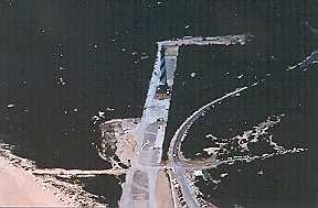 photo by Mike Booher |
|---|
The act does not mandate the automatic preservation all historic properties. The act does mandate a management and consultation process between federal agencies and state and federal preservation officials. In this instance the, North Carolina State Historic Preservation officer concurred that relocating the light station afforded the best means of the protecting the resource.
An array of federal statutes and regulations govern development and protection of the coast as well as contiguous marine areas. These laws discourage efforts to harden or artificially stabilize retreating shorelines .
In selecting an option or combination of options to preserve the lighthouse, NPS had to comply with public policies concerning historic preservation as well as those concerning coastal management and protection. This case posed a potential conflict between policies that would preserve the historic lighthouse and policies that would allow natural processes to occur unimpeded. With its dual mandates of historic preservation and conservation of natural areas, NPS must deal with such conflicts. The relocation option presented the best solution to meet the intent of both policies.
Another conflict included local opposition to the move. Opponents held doubts on the technical feasibility and safety of the move, belief that preservation in place would be more cost effective, and that the loss of site integrity was unacceptable. The 1988 NAS report and subsequent documents thoroughly refuted these concerns. Never-the-less some among the local community remained unconvinced.
Design-Build Contracting Method:
The 1988 NAS Committee report had recommended the contract be award as a single contract for the design and implementation of the move. This single contract, known as a “design-build” contract presented new approach for the National Park Service. This method allowed the contract award to be based upon the “best value” to the government as opposed to more traditional low bid award process.
The National Park Service appointed a contractor selection committee that included NPS structural and construction engineers and chaired by the author. NPS also placed two outside advisory panel members who had served on the 1988 NAS and the 1997 North Carolina State University committees.
In December 1997 NPS issued a request for contractor qualifications. Six firms submitted qualification packages for consideration by the selection committee. All the firms were experienced in moving large heavy pieces of equipment and buildings. A few of these had had experience in moving historic masonry buildings. Only the International Chimney Corporation had actually moved other masonry lighthouses. None of the firms had ever moved anything as tall or with the load concentration of the Cape Hatteras Light house.
Two of the firms were found to be highly qualified firms. These two forms received the full request for proposal (RFP) package that outlined the full requirements of the project. The firms had 8 weeks to develop a technical and price proposals for the consideration by the selection committee.
The technical proposals were evaluated against criteria that included suitability and reliability of all aspects of the work, protection of the historic structures’ fabric and management organization of the project by the firm.
Scheduling criteria required that the light house be moved onto its new foundation to avoid the extreme weather from “nor’easters” (winter storms along the American Atlantic coast with driving winds that come out of the northeast) and hurricanes. This meant moving of the light house must occur in the 3 month window of good weather between April and July.
The selection committee awarded the contract to the International Chimney Corporation.
| The contractor estimated the lighthouse move weight at over 4000 metric tons. The preparatory work phase included the identification and installation of bracing, reinforcing, or structural enhancement at all the structures. Brickwork inspection, necessary splinting, exterior plinth reinforcement, entry stairway removal and entryway bracing were part of the necessary preparation. for the lighthouse move. The next step entailed foundation removal and installation of temporary support. Cutting and coring operations selectively removed portions of the existing foundation in order to insert the steel support frame. A 3/8” heavy duty diamond cable wire saw created the separation plane. The foundation stone below was removed and when the existing wooden foundation mat was exposed, shoring towers were installed. The main and cross steel beams were then put in place. |
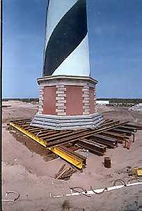 photo by Mike Booher |
|---|
| During the structure load transfer and lifting phase, the lighthouse gradually transferred from the temporary support to the support steel frame. A unified hydraulics system (all lifting points rise at the same rate) lifted the lighthouse off its foundation and relocation equipment was installed underneath. The contractor used the same system to lift and move the Principal and Double Keepers Quarters. |
| In the relocation phase, the lighthouse traveled on steel rails or tracks to its new site. An “I” beam matting was placed over improved soils to the edge of the excavation and the track placed under the lighthouse and the already installed main beams and roller dollies. Push jacks were then installed between the track steel and the main beams. The crew then activated the push jacks in unified hydraulics. At the end of each 5-foot stroke, the jacks were to be retracted, the system re-charged, and readied for the next 5-foot stroke. Only a third of the travel system was placed at any one time. |
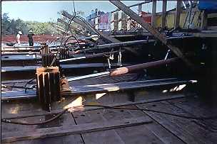 photo by Mike Booher |
|---|
As the transportation system and the lighthouse move past a point, the part of the system already used, the crews retrieved the I beam matting and leap-frogged it ahead. The double keeper’s quarters and primary keeper’s quarters will be transported via rubber tired dollies to their new location .
| Common to the relocation phase for the lighthouse, double keeper’s quarters, and principal keeper’s quarters is the concept of cushioning the structure on hydraulics jacks. The three zone hydraulic system concept enjoys wide use in structure relocation projects. Fundamental to this is that three points determine a plane. The structure rests on a steel grid set to maintain the structure’s horizontal and vertical axes. The crew monitors the pressures in the jacks constantly during the move along with monitoring additional instruments checking the horizontal and vertical alignment of the lighthouse. With this hydraulics system the operators make corrections to keep the structure sitting on in a uniform plane even if traveling over inconsistencies in the move route. This type of move system (known as a “soft move”) mitigates transmission of the stress to the structure. A rough analogy would be shock absorbers as found on a car. |
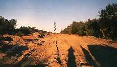 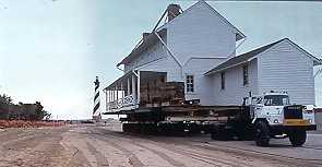 photo by Mike Booher |
Upon the lighthouse‘s arrival at the new site, it was lowered and its weight transferred to the new foundation. The process was essentially the reverse of the procedure used to lift the lighthouse. The new foundation mat has been constructed of reinforced concrete 1.2 meters thick. The Lighthouse and associated buildings were be set to elevations that will lift them above the 100 year flood plain. They will be set in the same spatial relationship to one another and relative elevations and to true north as originally constructed.
Conclusion
The primary structures forming the Cape Hatteras Light Station remain from their original construction in the mid to late 19th century. Though, the have been altered and/or renovated over time, historic changes represent the historic progression of enlargement and alteration of any light station and do not detract from their overall historic integrity.
The decision process to relocate the light station involved scientific investigation, public involvement and use of the techniques providing the best opportunities for preserving the structures.
The Cape Hatteras Light Station relocation project exemplifies the decision making process where the responses to the threat from natural forces were balanced against cultural and natural resource needs.
The National Park Service designated the Cape Hatteras Light Station as a National Historic Landmark in August 1998. The American Society of Civil Engineers designated the lighthouse a civil engineering historic landmark on October 18, 1999.
The Cape Hatteras Lighthouse has come to symbolize the efforts of the hundreds of individuals who kept the lights burning along America’s coasts. The light will once again flash across Hatteras Island and Diamond Shoals as the twenty-first century begins.
Selected Bibliography
Saving the Cape Hatteras Lighthouse From the Sea: Options and Policy Implications. Committee on Options for Preserving Cape Hatteras Lighthouse, National Research Council, National Academy of Sciences, Washington DC 1988.
Saving the Cape Hatteras Lighthouse From the Sea: Review and Update of the 1988 National Research Council Report Ad Hoc Committee of Faculty at North Carolina State University, January 1997.
Cape Hatteras Lighthouse Complex, Protection Alternatives, Development Concept Plan/ Environmental Assessment. National Park Service, Denver Service Center, 1990
Moving Hatteras, Roberts, Cheryl and Bruce, Lighthouse Publications February 1999
Cape Hatteras Light Station, National Historic Landmark Nomination, National Park Service, August 1998
Cape Hatteras Lighthouse, Comprehensive Structural Analysis Report. Hasbrouch Hunderman Architects with Wiss Janey Elstner, March 1986.
Keeper’s Dwelling, Cape Hatteras Light Station Historic Structure Report Part I, National Park Service, December 1968.
Cape Hatteras National Seashore -Lighthouse Relocation Articles and Images
Outer Banks Lighthouse Society
Federal Preservation Forum
International Council on Monuments and Sites
US National Committee of ICOMOS
WRAL On line-Efforts to move the Cape Hattras Lighthouse Underway
Return to Table of Contents
Paul Cloyd Copyright © 1999
Please email your comments or questions to p_cloyd@msn.com
This site is sponsored by Art Itself